Home / Islands / Ōsakikamijima Island
Ōsakikamijima Island 大崎上島
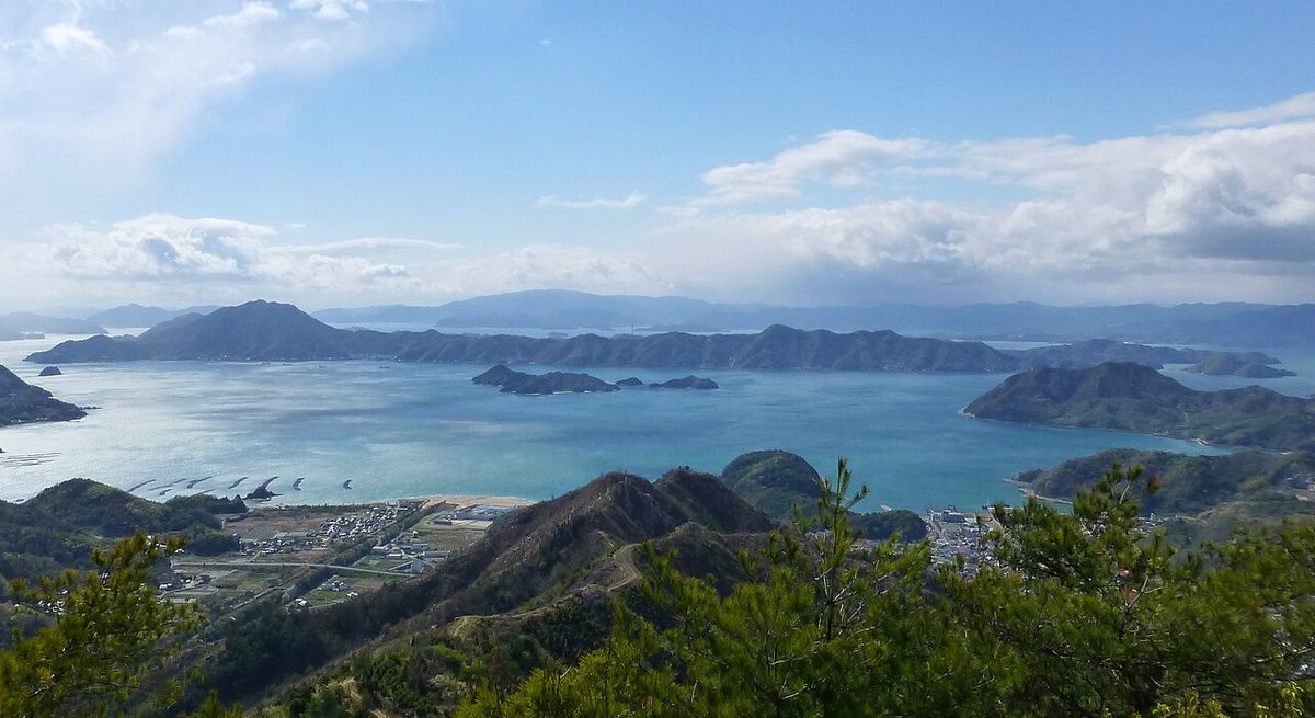

| Island group | Geiyo Islands |
|---|---|
| Prefecture | Hiroshima |
| Region | Chugoku |
| Municipality | Ōsakikamijima |
| Area | 38.27 km² (14.8 mi²) |
| Highest point | 453 m |
| Coordinates | 34.24528° N, 132.89472° E |
Getting there: the article below outlines this island's usual ferry and flight routes. Timetables change with the season and sailings are cancelled in rough weather — always confirm the current schedule with the operator or the municipality before you travel.
Ōsakikamijima Island is the island of the Inland Sea Forecast Islands.
Geography
It's about 10 kilometers south of Toshihara, Honahara. A little farther south west is Ōsakishimojima in Wu. XXQ176X on the south side, Ōmishima Island on the east side and ZXXQ21616X on the south side. The northern coast of the island is the country's natural monument to the Snalmel The area is 38.27 km (as of October 2014). It's a long stretch to the northeast and to the southwest, and it's about eight or nine kilometers to the north. The highest peak is designated as the special area of Japan's Inland Sea Park. The whole island is almost hilly and the plain is narrow. The east side of the island forms a spine that narrows down to the coast and places a community in the cove. The west side of the island, on the other hand, has a relatively open plain formed from a tap and becomes the center of the island. The coastline is almost in. The climate section is the Inland Sea climate. Geography is almost granite. The population on the island is 7,158 today. Between 2000 and 2010, the population dropped 16.2 percent, and the rate of aging in 2010 was 43.0 percent. Young and old are getting older. The administrative section is Ōsakikamijima Island. The following list of addresses in postcode order. 725-0231. 725-0301 in Nakano. 725-0302. 725-0303. 725-0401 From the Yae. 725-0402. 725-2004 Akira Akira. The stadium has headquarters in Togo, in the northern west of the island. There are Ozaki's office in Nakano, and a yagi station in the Tokyo Ee. The main industry is the manufacturing industry of farming and building ships, which are centered around citrus rice. Today, in 2010, industrial expositors are working with the 1st 580 farmers 542/38 fishermen. However, there is a decline in every industry in every industry between 2000 and 2010, with a decline of over 25 percent in every industry and a marked decline in every industry. The water supply is connected by underwater water pipes from the main state. As of 2012, the distribution rate is 99%. The sewers are being processed at a rate of 68.0 percent and as of 2012, but the water distribution rate for urination planning and water disposal is 100% in proportion. Medical institutions have six clinics, four dentists, and 45 beds. I've also got a helicopter transport to emergency medicine. Information networks such as mobile phones and fiber optics have been built. Traffic from Honshu and other islands is limited to passing ships.
Ancient
Prehistoric ruins have been found in the wild islands and mills in the Ozaki Islands, but not in Ōsakikamijima Island. In particular, on the island of Fukushima, sites have been discovered from the time of the Great War, some of which have been found salting pottery, but none of them have been found in the zXQ036X above the west coast. When zXQ036X comes up with buried cultural goods, it's from the old days. It's also biased to the west. A typical one is the ruins of Seyoi and the Long pines of Great Britain, where salt pottery has been found, and at least salting has been done since this time. Old age is also located in the west, and they are both small. The Seyi has a bone from the Seyee 1 to 4, and the one and three and four are found buried in the remains of only boxed sarcophagus, 2 and 4 in the city of Ōsakikamijima Island. In other words, in the Middle East, it's the town's history.
The villa and the pirates
During the Middle Ages, this island was the residence of Greatzaki's house. According to the records, the name of the Oksaki house appears in the Kingsguard's domain. In addition to this, the names of Nakasaki Nakasaki are kept on record. The year was salt, as well as other islands in the Inland Sea. The bringing of salt into the sea will create a network of pirates that would rule the seaways as seafarers. There were pirates on this island, and eventually they became a group called the Greatzakis. As a group of Osamasakis, the name is written in the Kusakasakis, the Lord of the Sun, the Lord of the Sun, the Lord of the Sun, the Lord of the Sun, the Lord of the Sun, There are twelve medieval castles all over the island, but these are thought to be built in a struggle for territory between Mr. Kusaki's people or the Isegawas and the Coast Guard and other Iseshima pirates. At the time of the war, the Osakisakis will be under the victory umbrella of the Fukugawa family, based on the sea. According to the record, before the battle of Terashima, it was built into the hairline and is armed with the battle of the First-Saigawa. The pirates will be defeated by a cease-fire. The Kane has become a ship's port in the role of Fukui Kogi. From medieval to early Edo, Ōsakikamijima Island went by the name of Ozaki Island. For example, it is listed in the Old Testament books of the 5th year of the year and in the early Edo journal, "Engdo" in its name. On the other hand, the current Ōsakishimojima was called "Shimoshima Island, Amakusa or Hand Washing Island" by the middle ages. In Edo period, Ōsakikamijima Island XZX216X became a Hiroshima storage facility.
The cruise ship and the built ship
During the Edo period, salting and fishing flourished in this land. At the end of the season, most of the people of the island are involved in seagoing operations, and according to the trading records of the last days of the seafaring officer, the passengers in Osakishima are believed to have used over a hundred tons of ships and small craft to deal in daily supplies around the advanced islands. The ship was originally centered on Kurahashi-jima in Hiroshima, but when the time came, it became popular on this island. It was said that there were 1,000 stone ships and many shipowners. One of them is a sailor's house. This house became one of the best sealocks on the island when it came to entering the Meiji era. When this moon house was to take over coal transportation from Nagasaki's Takashima and Matsushima Mining Company during the Miyaji period, it grew up on the island, especially the tin eve, as a base for shipping to nearby coal. The Nintendo family is a political family, and they serve them. And in modern times, from building wooden ships to building modern steel ships. This is one of the reasons why coal transport stations have been launched, and the east side of the island has been the main route to the ocean in modern times, called the "Santo Inland Road" and has been changed to meet the demands of the times. At one time during the Showa season, in an internal ship made up nearly 30 percent of the national share. Just after the oil shock, the ship's recession has been affected and decommissioned.
The bridge plan
Ōsakikamijima Island is the largest island in Hiroshima as remote islands. As of 2016, the only Ōsakikamijima Island bridge in Ōsakikamijima Island will be the Long Island Bridge tied to Long Island by Chinese power. Here are some plans for the bridge. There's a plan built into this to connect you from Okamura Island, Ehime, as the bridge 8 is. The XXQ036X Project was formed and chose its own bridge route. It's decided on a bridge route connecting Akishima-Santa from Tohara City. There's also a bridge project that connects only Toshishima.
To the island of education
There's a Hiroshima trading school on the island. The beginning of the school was during the Meiji era, when navigation on the island took place. In addition, villages like Ikuchijima, Takashima and Tsukishima have also joined the union as an armored captain's training school and have been changed to a trade ship school under the command of a business school (in 1899) and continues to continue to this day. The government decided that Japan's resuscitation strategy would lead to a massive increase in international Kashlore-approved schools.
Cultural goods
The cultural treasure of the country and county - Mount Fuji, the god of Japan's national park, the main area of the Seshango National Park. The culture of the town, as well as the Ōsakikamijima Island horse race - 100 landscapes of treasure on the island and the history of the sea and the island.
A good name
Here I'm going to list the main attractions introduced at the Town Tourism Society other than those mentioned above. It's just like the old town of Kane. It's called "The Natural History of Japan." It's a safe house. Arguite. I'm sure you'll be pleased to meet me.
Hot springs
A hot spring. Hot springs of medicine.
The work Loque
In 2013, a clinic on the sea. My wife, 2018, like the rose, it's hard for my family.
Traffic
Here's a list of the transportations introduced by the City Tourism Society. As above, transportation is the only way to get across. The ferry port - Whitewater Port - Kusai, Kusai Bay. A fast ship, the port of Toshihara - the port of Toshihara - the port of Tohoku - the port of Okinawa - the port of Akira. The ferry harbor - Akira. The ferry is now in the port of Seikichi-Suji - Kanaki. The ferry port - Kinoshima - Akishima - Akishima (Ōsakikamijima Island town ferry)
References
"\t\tThe Institute of Inland Culture" 9; Hiroshima University Institute for Insea Culture, March 30, 1981, pages 56-87, ISSN 86-3182; 201616. Haneda book shop, Akitsuke's Letter to the Akimatsu Group, 1945. https: / /dl. ndl. go. View October 21st, 2016. Introducing ISSN12-5744, ISSN12-5744, October 21st, 2010. Archive from June 26, 2015. View October 21st, 2016.
Text adapted from the Japanese Wikipedia article 大崎上島, whose full text was translated into English for this guide by its contributors, licensed CC BY-SA 4.0. Population, area and location facts from Wikidata (CC0); figures Wikidata does not carry are taken from the Japanese Wikipedia article's data table (CC BY-SA 4.0).